This LAS-converter is available also in 32-bit version, but supports only LAS versions 1.0-1.2. New Las2-converter is available only in 64-bit version and supports also LAS version 1.4 files.
LAS files are binary files is used to store LIDAR (Light Detection and Ranging) data. Files contain only points and are typically quite large.
Files with the LAZ extension are compressed LAS-files. Converter recognizes them automatically and reads them just like ordinary uncompressed LAS files. If the laz extension is used in writing, converter writes compressed file.
By default all points are read from the file. With the content function only points with given classifications are read. Common converter settings keep codes and skip codes can also be used to filter classifications during the reading.
If common converter settings have coordinate minimum and maximum values defined, they are checked during reading. If the conversion contains some coordinate transformation, the minimum and maximum coordinate limits and possible line filtering file shouls be in final result coordinate system.
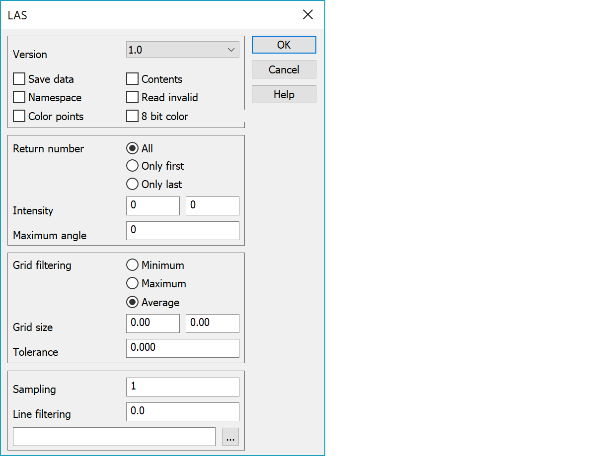
Written LAS file format version.
To save memory, only classification is stored to the field T3 by default. If this setting is on, other original point data is also stored:
These cover LAS-format point data record format 0 information. Information is needed, if points are later written to another LAS-file. If grid filtering average method is used, this information is not stored. Classification is stored to averaged points only, if all averaged points have same classification.
Adds namespace LAS to the code field of read points.
Automatically asks contents when reading.
Read also invalid points.
Reads or writes points as color points, which are drawn as colored squares. Color is transferred to the point draw data from the LAS point and default size is calculated from the average point density. Size or its multiplier can also be given in SymbolSize-settings in field settings.
Reads or writes 8 bit RGB components. 16 bit components are assumed by default.
Leaves either all same signal return numbers or only the first/last.
Filters points with intensity outside minimum and maximum values or angle above maximum. Value zero in fields skips checking of that value.
If the grid size id given, grid filtering is used. All points are read to lightweight point construct, ordered according coordinates and filtered so, that only one point is left to each square. Point height is either grid minimum, maximum or average.
If grid filtering is used with color points and average setting, result color is average of original point colors. This is done simply by taking average of each color component (red, green, blue).
Tolerance Z setting can be used for height tolerance. If point height differences withing grid square are larger, square is divided to smaller quarters until all point heights are inside given tolerance. Right side field of Grid size setting determines the minimum grid size. Squares smaller than that are not divided to quarters.
Simple test filtering, that reads points from the file with given interval. Affects last after classification and coordinate filtering.
Line filtering works with vector file containing breaklines and the fetch distance. The upper field contains the fetch distance and the lower field vector file, which should be in 3D binary format. Filtering checks all breaklines in the given file. If the line is closed area, points inside it are accepted. Otherwise points within given fetch distance from the line are accepted. If file name is given as * (asterisk), the active file in element list us used.
There are some special settings related to this converter.
Comma separated list of own codes appended to the content list after standard LAS codes. Code can contain also description part separated by equal sign. If the description contains spaces, it must be enclosed within quotes (e.g. 21=code,22="other code").
See also: Common special settings