Reads and writes Maagis/XL transfer files.
When writing Maagis-format, breakline heights are checked. If all points have equal height, this line is taken as contour and heigth information is included in line header information (VI-line) and height of the line points are set to zero. When reading Maagis-format and line header information has a non zero height, all the points on this line get same height.
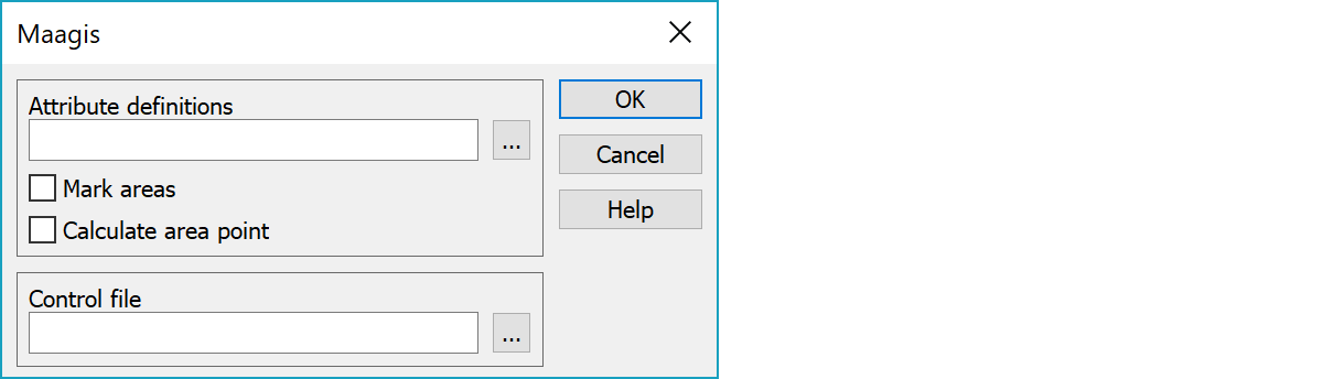
If control file is defined, feature code (T3) in reading is taken from conversion table and T1 gets 0, otherwise T1 gets Maagis group and T3 gets Maagis class. Writing makes same conversion to other direction. If the T2 field has defined default value, it is used in reading. Otherwise target address id stored to T2. Target address of a line point is point number, if no default value is defined for T4 code field.
GIS-attribute name change table file.
Marks closed breaklines as areas.
Calculates area point for closed breaklines. The calculated point is always inside the area.
Control file for code conversion.
Defines conversion between 3D-Win code and two Maagis codes. The first number is 3D-Win code (T3). Second and third numbers are Maagis group and code. Without control file T1 is group and T3 is code.
Additionally lines can have target group (fourth number). If no target group is defined, the following default values are used:
linegroup pointgroup
19 1
20 10
21 11
n n+10
Example:
101  27 27411 37    // explanation
102  27 27412       // explanation
212  52 63412 11
Maagis-formaat lines may have attribute data. 3D-Win uses following id for Maagis attributes:
VIRHE keskivirhe
TAPA määritystapaluokka
LAATU laatukoodi
VARMA epävarmuus
TIEOSA tieosanumero
TIENRO tienumero
TOSI todellisuus
TOIMITUS maanmittaustoimitustieto
ALUE alueen luokka
KORKEUS kulkukorkeusrajoitteen korkeus
LEIKKAUS leikattavuus
MUODOST alueen muodostus
NAKYVA näkyvyys
TASOSIJ tasosijainti
VALMIUS tien valmiusaste
TIEPINTA tien pinta
SUUNTAIS tien yksisuuntaisuus
LASKENTA laskentanumero
PREA
SE   6697132.756   3444210.952     7.459         9       420      3204         0         0         0         0
SE   6697132.847   3444209.549     7.537         9       420      3205         0         0         0         0
SE   6697121.180   3444207.073    10.273         9       234      3206         0         0         0         0
SE   6697187.536   3444378.318    16.453         1         0      3137         0         0         0         0
SE   6697193.242   3444377.758    17.088         1         0      3138         0         0         0         0
VI         1       123       501         0         0         0         0         0         1         0         0        11         0        11         0        11        45         0         0         0         0         0         0         0         0         0         0         0         0         0         0         0         0         0
VP   6697095.630   3444136.431     8.716        11      2326
VP   6697097.182   3444147.189     8.227        11      2327
VP   6697098.268   3444164.049     7.683        11      2328
VP   6697100.898   3444181.102     7.310        11      2329
VI         1       121       502         0         0         0         0         0         1         0         0        11         0        11         0        11        45         0         0         0         0         0         0         0         0         0         0         0         0         0         0         0         0         0
VP   6697099.749   3444142.262     8.549        11      2392
VP   6697100.635   3444155.809     8.035        11      2393
VP   6697102.206   3444172.439     7.585        11      2394
VP   6697105.424   3444188.346     7.347        11      2395
TE   6697150.522   3444163.549     8.540         0         2         0         0         0         0        -0         0         0         0         9Grankulla
TE   6697195.116   3444390.328    16.714         0         3         0         0         0         0        -0         0         0         0        13Mjölnarbacken
There are some special settings related to this converter.
Default value for mean error. Given in millimeters.
Priority record written to the beginning of the file:: PRAL (areas), PREA (no areas, default) or PRAK (areas + targets).
Last line feed is not written to the file.
Using SY-type point as single point and/or text only.
0 = text point remains and single point attribute is set to text value
1 = T4-field of single point get text value and text point is removed.
Default ladontakoodi in writing. If point or line has value in the field T5, it will be used as ladontakoodi.
See also: Common special settings